Stranger still, the borders shift in the mass media depending on what type of story is being reported. Here in Chicago's Near Northwest, if a trendy new restaurant opens it's on the North Side, but if someone gets shot, it's on the West Side. This is true even if the shooting occurs north and east of the restaurant!
In Chicago parlance, "West Side" means ghetto, crime, ignorance, hopelessness, decline, decay, futility. It means empty lots, shut down factories, abandoned dreams. Most of all, it means the '68 riots that broke out after Dr. King was assassinated, from which some neighborhoods have never recovered. So the phrase "shooting on the West Side" contains a lot of unspoken subtext for a Chicago audience. As a result, no one wants to say they live on the West Side. This is why developers always want to push neighborhood boundaries westward: Bucktown was once marketed as "West DePaul": now that it's "gentrified," Humboldt Park is being marketed as "West Bucktown."
This is also why so many people west of the rivers want to defect. Take Little Village. First they didn't want to be known as South Lawndale anymore (to escape the stigma of association with North Lawndale), now many residents will tell you they live on the Southwest Side. The same goes for Logan Square, which I've heard referred to more than once as a "North Side neighborhood." Is it? Where should one draw the line? Eric Zorn tried heroically to answer this question in today's Tribune, but fell short (for one thing, but setting the West Side's southern border at 25th street, he has located the West Side's premier shopping district, West 26th Street, on the South Side!. A prime example of everything good being magically relocated out of the West Side). I will try my best to rectify the situation, and hopefully restore the West Side to its righful place on the city map.
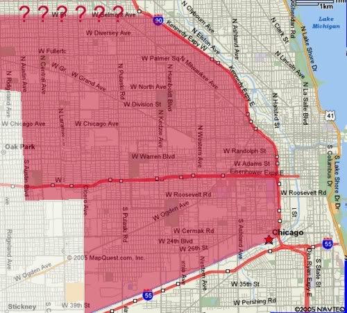
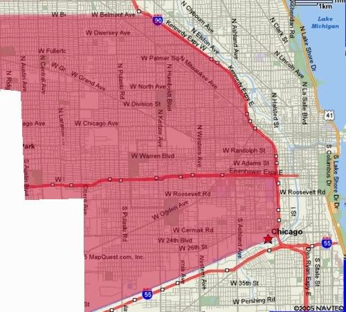
A brief inspection of a city map suggests a West Side far larger than current denials would have you suggest. On most sides it is defined by clear geographical or political boundaries: City limits on the west, the Sanitary and Ship Canal on the south, the Dan Ryan and Kennedy Expressways on the east. The San is an obvious border because it's such a pain to cross, there are only a few major roads which cross the water uninterrupted, and it's often a pain to find one when you're late for an appointment on the other side. In no case does a neighborhood overlap the San. If this isn't a border, I don' know what is.
This solves the problem of Little Village as well, placing the entire neighborhood, including West 26th Street, on the West Side where it belongs. But where should we put the northern border?
Let me start with what I'm absolutely sure of. My part of town, what I've been calling the "Near Northwest," consists of Bucktown, Wicker Park, the Ukranian Village, and Noble Square. These four smallish neighborhoods really form a single community area, with clearly defined borders at the Kennedy Expressway to the east, Western Avenue to the West, and Chicago Avenue to the south. This area should be considered as a unit.
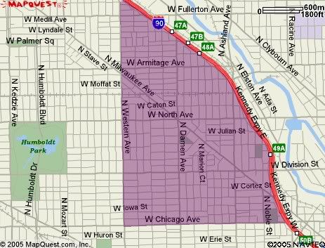
If we wish to maintain the territorial integrity of this area, then obviously you can't use either North or Armitage as the West/Northwest border. They don't make sense anyway. North Avenue is a busy but narrow neighborhood commercial street. It contains people, it doesn't divide them. Armitage isn't a border of any kind in this part of town, and cuts right through the heart of Bucktown. To argue that half the neighborhood is on each "Side" is to be painfully silly.
So where is the border? Fullerton? This solves the problem of Bucktown, but now Logan Square is cut in two. If we follow the rule of thumb that cohesive neighborhoods shouldn't be divided between Sides, the border will have to be set either way down south at Chicago Avenue, or all the way up at Belmont.
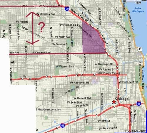
Many Chicagoans, given this choice, will choose Chicago as the border. This puts the Near Northwest bloc on the Northwest Side, but also takes along Humbolt Park and North Autin, two neighborhoods which are widely accepted as part of the West Side.
Now, some may argue that this is the case. There are many newcomers in Wicker Park and Bucktown who claim that the West Side begins at Western, a road which some refuse to cross. They themselves claim to live on the Northwest Side, or even on the North Side. Such claims defy logic and if true defeat the purpose of grouping neighborhoods into geographical regions. Western Avenue may still be a neighorhood border, and to some people a class divide, but it certainly is not a border between the Northwest and West Sides.
Which leaves us with Belmont. This border puts the Near Northwest on the West Side, along with Humboldt Park. The geographic layout of the city becomes clear and easy to understand, and no major borders cut through cohesive neighborhoods. The major argument against this border will be that the Belmont-Craigin and Montclare neighborhoods are "nice", therefore they can't be West Side. But that was my whole point - our expanding definition of the West Side defines an area as diverse and interesting as any of the other regions of the city, and allows us to look at troubled West Side neighorhoods in their proper context, with the people who, in many cases, live right across the street from them.
Welcome to the West Side, neighbors.
The restored West Side
7 comments:
Just popped over to say HAPPY BIRTHDAY!!
I'll second that -- HAPPY B-DAY!
I just moved to Little Village so this subject came up before the Hothouse Flowers concert (when was that? February?). Anyway, the conversation that night was about North, West and South and seemed to settle on the canal and the North Branch of the river as separating everything nicely into 3. (One person had this weird view in his head that the west side was something of a rectangle, Chicago Ave to Roosevelt and Halstead to the city limits.)
Anyway, I'm happy to live on the west side in Little Village but you seem to imply (as does Eric Zorn) that there are Northwest and Southwest sides as well. Where are they in your estimation?
Has anyone else noticed as well all the new names coming up for various sub-parts of the West side, i.e. "West Corridor", "River West", "West Loop", "Near West". Who konws what to call anything anymore!
Ted -
Most people would say the Southwest Side is south of the Sanitary and Ship Canal, and west of Western Ave. I would include Beverly and Morgan Park even though they are east of Western simply because they form the Southwest border of the city. Others will say the two neighborhoods are the Far South Side.
The Northwest Side is west of the river and the North Shore Channel, and north of whatever you think the northern border of the West Side is. I'm sticking with Belmont, but some people will argue for Fullerton, Armitage or North Ave. I don't like those borders simply because they cut neighborhoods in half: how can a single 'hood be on two "Sides" of the city?
Makes sense to me. Thanks!
to keep it consistent, make the northern border od the west everything south of I-90(as it starts to go west, by ohare airport. that way, everything south and west of I-90/94, north of I-55/the shipping canal and east of the city border-makes the most sense to me----all of the northwest is part of the westsdie where it should be-i hate the ambiguity of the our city.
Post a Comment